The Puerto Princesa Subterranean River National Park (PPSRNP), formerly known as St. Paul's Subterranean River National Park or St. Paul Underground River, is found in the St. Paul Mountain Range about 76 kilometres northwest of Puerto Princesa City, Palawan, approximately 365 nautical miles south of Manila, facing the West Philippine Sea with geographic coordinates 10′ 10 north, 118′ 55 south. It is bordered by St. Paul Bay to the north and the Babuyan River to the east. The topography varies from flat plains to rolling hinterlands and hills to mountain peaks. Over 90% of the park comprises sharp, karst limestone ridges around Mount St Paul, which is itself part of a series of rounded, limestone peaks aligned on a north-south axis, along the western coast of Palawan.
 |
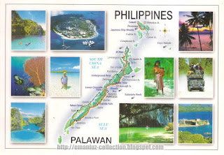
| Mapcard of Palawan, Philippines |
The area also represents a habitat for biodiversity conservation. The site contains a full mountain-to-the-sea ecosystem and has some of the most important forests in Asia. It was inscribed by UNESCO as a World Heritage Site on December 4, 1999.
To vote for Puerto Princesa Underground River for the New 7 Wonders of Nature, visit www.new7wonders.com, or text PPUR to 2861. Please support Puerto Princesa Underground River!


Count my vote.Let us support Puerto Princesa Underground River.
ReplyDeleteHello, congratulations on the post! I am a Brazilian professor and I am writing a book about world heritage sites, to be plubished in Englihs by Spring editions. I am coming to ask you if would be possible to use two of your photos to illustrate my book. All the credits would be given. I thank you very much for the kindness of an answer! Kind regards, Vanda Claudino Sales
ReplyDelete